Map Skills Practice Worksheet: A Complete Guide for Teachers and Parents
Developing strong map‑reading abilities early on sets the foundation for geography, mathematics, and everyday navigation. A Map Skills Practice Worksheet gives students a structured way to explore latitude, longitude, grid references, and basic map symbols while reinforcing classroom learning. This article explains why worksheets are essential, how to choose or create effective ones, and practical tips for using them in Year 3, 2nd grade, or any early‑elementary setting.
Why Use a Map Skills Practice Worksheet?
Worksheets provide a tangible, low‑tech complement to digital lessons. They allow learners to:
- Practice reading a simple grid without distractions.
- Apply concepts such as latitude and longitude in a hands‑on format.
- Develop spatial reasoning by locating points, drawing routes, and measuring distances.
- Receive immediate feedback through teacher‑marked answers.
In the classroom, a worksheet can be paired with a video lesson—such as the Year 3 maths video where students turn their classroom into a simple top‑view map—to reinforce visual learning with written practice.
Key Components of an Effective Worksheet
A well‑designed Map Skills Practice Worksheet should contain the following elements:
- Clear objectives – State what skill the student will master (e.g., “Identify latitude lines on a world map”).
- Simple grid layout – Provide a grid with labeled rows and columns so learners can practice coordinates.
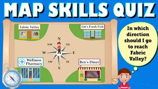
- Real‑world context – Use familiar settings like a school playground, a local park, or an Ordnance Survey map of the Lake District to make tasks meaningful.
- Varied question types – Include matching, fill‑in‑the‑blank, and short‑answer items to address different learning styles.
- Answer key – Offer a concise key for quick teacher grading or self‑assessment.
Sample Worksheet Activities
Below are three activity ideas that can be adapted for any grade level.
1. Grid‑Reference HuntStudents receive a blank grid labeled A‑J (columns) and 1‑10 (rows). The teacher reads a series of coordinates, such as “B4” or “H9,” and learners shade the corresponding squares. This exercise builds confidence in reading a simple grid.
2. Latitude & Longitude Match‑UpProvide a world map with latitude lines (parallels) and longitude lines (meridians) lightly drawn. In the worksheet, list several cities and ask students to draw a line from the city name to its correct coordinate pair (e.g., “Edinburgh – 55° N, 3° W”). This aligns with the “Learn about latitude, longitude” prompt.
3. Create Your Own Classroom MapInspired by the Year 3 maths video, students sketch a top‑view map of their classroom. They label desks, the door, and a “treasure chest” location. Then, using a worksheet grid, they write the grid references